The road: Jels - Rødekro
Distance: 1.14 Km
| +45 73 54 56 30 | bureau@visithaderslev.dk | http://www.haervej.dk/ |
Lace up your hiking boots or hop on the bike and follow the old Hærvej on the stages between Jels-Rødekro, which runs through Haderslev municipality and ACTURE PARK.
Updated by: Destination Sønderjylland - Haderslev | bureau@visithaderslev.dk
Stage 1: Jels to Vojens (Hiking stage 20: 21,5 km) (Cycling stage 14: 17,6 km)
The trip from Jels to Vojens goes through some beautiful natural areas, such as Stursbøl Plantage and Oksenvad Heath along Nørre Å. There is a selection of different activities for the whole family in Vojens.
Stursbøl Plantation
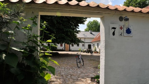
Stursbøl Plantation is located on the ridge where only a few streams are to be crossed. The place has probably been used by the traveler for millennia. The connection to ancient times is especially seen by the total of 70 Bronze Age hills, which are adjacent to the army tracks. South of the plantation you pass the old army road in Stursbøl, which today has the name Café Ellegård, which among other things houses a hostel.
Then follow the cycle route on the outskirts of Oksenvad Hede, where you are led down to Slevad Bro. The road tracks show that early travelers have also used the crossing at Slevad and Oksenvad.
A sign indicates a grave mound from the Iron Age. As the mound has been uncovered, you can see its structure with a double stone ring.
Road trip
In Vojens, there is the opportunity to shop and throw yourself into a lot of active offers, including go-carts on Denmark's largest outdoor go-cart track at Kart Racing Vojens, or perhaps a dip in the swimming pool at Vojens Hallerne. Tørning Mill, which is located south-east of Vojens, is a beautiful natural area, which is naturally up for a break. Explore the old watermill and feel the buzz of history when you stand on the hill that once housed Southern Jutland's oldest medieval castle. Make a detour to the hydropower plant in Christiansdal or Denmark's second largest zoo beautifully located by Haderslev Dam.
Skrydstrup Woman
If you take a small detour from the route, you will find Denmark's second largest Bronze Age site, which was found in connection with excavations in 1993. The house may have been Skrydstruppigen's home. A little further southwest of Vojens towards Over Jerstal, you will find the mound in which Skrydstruppigen was found in 1935. The grave contained the body of a girl of about 19 years, who was buried in the middle of the older Bronze Age, approx. 1300 BC The find has been exhibited at the National Museum in Copenhagen, but at Haderslev Archaeological Museum you can see copies of Skrydstruppigen's costume.
2nd stage: Vojens - Rødekro (Hiking stage 21: 31,1 km) (Bicycle stage 15: 27,1 km)
The stage from Vojens to Rødekro offers several sights and cultural treasures. Among other things, you come down to the first of Hærvejen's characteristic bridges, Immervad bridge, which is one of only a handful of preserved bridges on the old Oksevej. You will also see Hærulfstenen on your way, and a little south of Hovslund Stationsby you will find the old mill from 1867, Damgård Mill.
Burial mounds around the Vedstede lakes
A few kilometers south of Skrydstruppigen's high by road between Vojens and Over Jerstal, there is a small group of burial mounds west of the road, to which there is public access. The tombs date from the middle part of the peasant age, ca. 3000 BC At Vedstedsøerne you will also find many well-preserved burial mounds, among others. northeast of Vedsted Church.
In Vedsted you can buy fresh supplies for the trip, or you can go for a walk on the path around Vedsted Lake, where at the southeast end there is an open-air bath and living area.
The long nozzles at Holmshus
A little south of Vedsted, you come down to Holmshus. Here is one of Jutland's most impressive tombs from the Stone Age, the long dolmens. It consists, among other things, of two parallel long dolmens that are over 100 m long. There is access to a large burial chamber (remember lantern), and above the large nozzle chamber is a 7 ton heavy deck. The construction of the dolmens represented an overwhelming effort at that time - 3200 BC.
The Hærvejs route takes you past the protected raised bog areas in Abkær Mose and Stengelmose. By the road between the bogs there are approx. 1/2 km west of the route a bird tower, from which you can look out over Abkær Mose.
Immervad bro
Then you head down towards Immervad Å which runs to the west, where it flows into Gels Å, which later becomes Ribe Å. Here you will also see the characteristic Immervad bridge, which since 1786 has given the traveler the opportunity to cross the river. It is built of a split boulder - the "forest bust", previously it was probably a wooden bridge, but the name Immervad suggests that the place was used as a ford before the bridges came into being. Fords and bridges have always been gathering places for travelers, and therefore there was also an inn here. Immervad Kro was known for its yellow peas and pork. Today the inn is closed, but there is a rest area and a farm with a hostel.
Hærulf Runestone
Just before you hit Hovslund Stationsby, there is a remarkable rune stone at the roadside. The inscription is not long - only the name "hærulf" - or "Hairulf" as the rune artist wrote in the 900th century. The stone was moved to Berlin as a German booty in 1864, and did not return until 1952, and it now stands in its original place. In the same place, east of the road, you can see a Bronze Age mound - Strangleshøj. South of the mound is a 2 m high monument. Legend has it that the stone turns when it smells like bread. There is access to the mound and the stone from the rest area by the road.
Damgaard Mill
When you come to Hovlund Stationsby there is an opportunity to shop. South of Hovslund Stationsby is Damgaard Mill, approx. 1 km west of Hærvejsruten. The mill is from 1867, and it has been beautifully restored. Among other things, it was used for buckwheat milling, and the plant, which is still intact, is the best preserved in Denmark. There is access to the mill from the main road under the railway or over Hovslund Stationsby (open 1 April - 1 November, 10-17).
Vendersvold
A few kilometers south of Øster Løgum is a fortification from the end of the 200s, Vendersvold. The plant has been approx. 3 km long, of which 500 m can be seen today. It consists of a rampart and a tomb north of which today is a hollow road. From the army road route, there is access from the rest area on Andholmvej. Approx. 1700 years after the construction of the violence, another defense facility was built on the site. At the western part of it is a well-preserved cannon battery - the "andholm battery" - from Sikringsstilling Nord.
Roedekro
Hærvejen goes right past the old inn in Rødekro, and further through Rødekro's main street. Most often the inn takes its name from the town, but in this case it is the other way around, as the inn from 1642 has given the town its name. In Rødekro it is again possible to shop. Just south of Rødekro by Rise Church stands a signpost from Chr. the 7th time at the roadside: "Weg nach Flensburg und Sleswich". The Romanesque church with wall anchors in the tower has a well-preserved furniture from the Middle Ages.
REMEMBER to download the Hærvejen app, which gives you a detailed map of the route and tells you where there are places to eat, accommodation and experiences along the way.
Updated by: Destination Sønderjylland - Haderslev | bureau@visithaderslev.dk
 Photographer: VisitHaderslev
 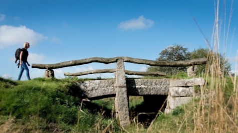 Photographer: VisitHaderslev Copyright: The highway secretariat
 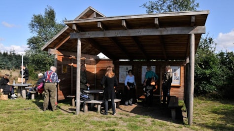 Photographer: VisitHaderslev
 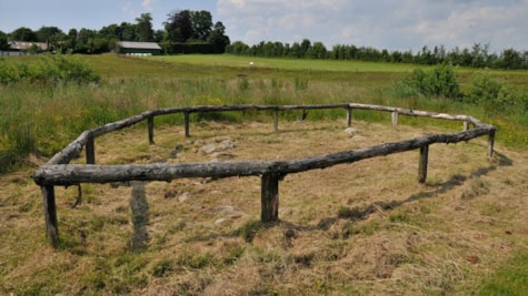 Photographer: VisitHaderslev